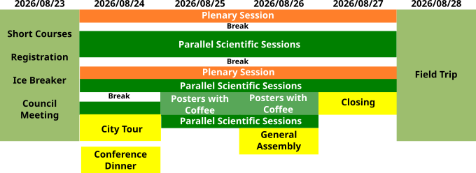
Scientific program
The conference welcomes contributions to all areas of mathematical geosciences and geoinformatics. Contributions can either be submitted to
- contributed focus sessions,
organized around current hot topics by conveners from these subject areas,
- or without a preselected session to general sessions
organized for clusters of topically related contributions by the sciencific committee.
Overview
Still subject to changes.
Contributed Sessions
The selection of a session is optional.
Click on the titles marked  to see a description.
to see a description. - Advances in Image Analysis and Machine Learning Algorithms for Quantitative Petrography: From Mineral Separates to Core Logging
L.Paul Bedard, Arnaud L. Back, Julien Maitre, Kevin BouchardMineral identification and segmentation are challenging yet crucial tasks in most geological studies. Conventional petrography, which depends on written descriptions, lacks numerical precision and is susceptible to inaccuracies and discrepancies. However, with the growing availability of imaging systems and recent advances in computer image analysis, the potential of quantitative petrography has increased significantly. Recent deep learning algorithms have made substantial progress in the area of mineral identification in thin sections, crushed and unconsolidated sediments. They now boast accuracy rates approaching 90%. There have been significant advancements in the segmentation of minerals in thin sections and drilling core images. However, developing a general model applicable to diverse geological contexts, including igneous, sedimentary, metamorphic, hydrothermally altered rocks, and mineral deposits, remains a challenge. Finally, quantitative descriptions of mineral shapes, which are essential for interpreting geological processes, have also seen substantial progress. This session invites talks on mineral identification and segmentation, quantitative petrography, and core logging processes. We encourage participants to present their work on these subjects, highlighting any innovative methods or cutting-edge technologies that address current challenges.
- AI-driven Mineral Prospectivity Modeling
Emmanuel John Carranza, Renguang ZuoMineral prospectivity modeling as a computer-based approach to delineate target areas for exploration of certain mineral deposits in a mineral system has evolved from being knowledge driven to artificial intelligence (AI)-driven. The applications of AI in mineral exploration are ever increasing nowadays to address the complexity of relationships among datasets and with known deposit occurrences. The session welcomes submissions for presentations of: (1) novel AI algorithms and applications for recognition and integration of geo-anomalies to support mineral exploration, in 2D or 3D; and (2) novel AI algorithms and applications for analysis and synthesis of a variety of geoscience datasets to model mineral prospectivity and associated uncertainty, in 2D or 3D.
- Special Scales in Geodata: Compositions, Distributions, Orientations and beyond
K. Gerald van den BoogaartGeodata often comes in special scales, like e.g. compositional data, particle or grain size distributions, crystallographic orientations, structural orientations, plate rotations, shape data, etc. There are certain common features in the statistical analysis of this kind of data, such the use of appropriate distances (e.g. Angles, Wasserstein, Aitchison), distance preserving transformations (e.g. log ratio transforms, spline projections, harmonic functions,...), operations consistent with the meaning of the data (perturbation, measure transport, rotation), and the need for post-processing and advanced interpretation of the results. This session invites methodological contributions and case studies in the analysis of this kind data, which takes special care for respecting the specifics of the relevant scale.
- Computational methods for quantifying hydrocarbon resource potential and exploration risk
Jingdu Yu, Weihong Liu, Qian ZhangAdvanced algorithms in hydrocarbon exploration and resource assessment, as well as risk computation, provide essential insights and strategies for exploration activities. This topic encompasses not only oil and gas but also resources such as uranium in sediments and helium in gas reservoirs. Developing methods for risk and potential analysis to achieve a higher degree of quantification is at the forefront of both theoretical and practical advancements in geology and exploration decision-making. We welcome the submission of methods and abstracts related to data fusion, geological information extraction, resource potential computation, risk quantification models for forecasting, seismic and well logging attributes from data processing, and mathematical data applications. Submissions should specifically link to hydrocarbon and associated resource assessment technologies. This topic holds significant potential and appeal for academic journals focusing on technological advancements and their practical applications in hydrocarbon exploration and exploitation.
- Big Data Mining & Artificial Intelligence in Solid Earth Science
Yongzhang Zhou, Marshall (Xiaogang) Ma, Hui Yang, Craig A. Knoblock, Francky FouedjioBig data and machine learning have brought earth resource and environmental study into an artificial-intelligence research stage. Big data mining, machine learning and artificial intelligence algorithms and models have been applied to study multi-scale and multi-type ore deposit exploration and environmental observation. This session is devoted to highlight recent progress in the research and applications of big data and machine learning in the fields of earth science. We welcomes all big data and AI-driven ideas and research to address the development, especially current and future challenges in big data mining and machine learning in geoscience. It will cover the latest data science and machine learning advancements in combining such multi-disciplinary data to enhance sustainable and efficient decision-making in ore deposit exploration and environmental observations. Studies using new data-driven approaches for geochemical data analysis, geological modeling, geophysical inversion, mineral exploration, decision-making under geological uncertainty, are encouraged.
- Theories and Practices in AI for Geosciences
Marshall (Xiaogang) Ma, Tao Wen, Anirudh PrabhuArtificial intelligence (AI) is rapidly reshaping how geoscientists analyze, model, and understand complex Earth systems. This session explores both the theoretical foundations and practical applications of AI in and across many fields in geosciences. We invite contributions that examine new methodological advances, such as knowledge graphs, deep learning, generative models, and foundation models, and their ability to capture spatial, temporal, and multiscale patterns in geoscientific data. Equally welcome are studies that highlight real-world implementations, including data integration, anomaly detection, simulation acceleration, uncertainty quantification, and decision-support tools for environmental and resource challenges. A central focus of the session is bridging theory and practice. For theories, we welcome thoughts and insights on how mathematical principles guide model development, how domain knowledge can be embedded into AI systems, and how AI methods can be validated against physical constraints and geoscientific understanding. For practices, we encourage case studies from fields such as geology, hydrology, geophysics, geochemistry, geomorphology, planetary science, and more. Overall, this session aims to foster a dialogue on rigorous, interpretable, and impactful AI approaches and envision a roadmap that can guide the future applications of AI in geoscience research.
- Geoinformatics for Mineral Exploration: Integrated Spatial Intelligence and Target Generation
Mana Rahimi, Vesa NykänenGeoinformatics brings together spatial data, digital mapping, and quantitative modelling to support mineral exploration from regional analysis to prospect-scale target definition. Today’s exploration teams work with multi-source datasets (geological, geophysical, geochemical, and Earth observation) across 2D, 3D, and time, and need integrated spatial intelligence to turn these complex data landscapes into actionable targets within realistic time and budget constraints. This session provides a forum for innovative concepts, methods, and operational workflows in applied geoinformatics for mineral exploration. We welcome contributions demonstrating how integrated spatial approaches—combining mapping, modelling, databases, visualization, and decision support—improve exploration targeting, support mineral systems thinking, and bridge the gap between research tools and exploration practice. Both methodological advances and significant case studies from industry, government, and academia are encouraged. Indicative topics include (but are not limited to): • Geoinformatics workflows for mineral exploration and target generation from multi-source data • Innovative approaches to spatial data processing and integration of geological, geophysical, geochemical, and remote sensing/Earth observation data • Mineral systems–based modelling applied to spatial prospectivity mapping for concept-to-target exploration workflows • Exploratory Data Analysis (EDA) to support data pre-preprocessing in mineral prospectivity mapping and target generation • Design and use of exploration geodatabases, data infrastructures, and FAIR geodata practices • Advanced methodologies for processing and analysing multi-/hyperspectral and multi-temporal remote sensing data in mineral exploration and target generation • GIS- and remote sensing–based methods for 2D/3D/4D geo-mapping and alteration/mineral system characterization • Data-, knowledge-, and hybrid-driven spatial models for exploration targeting and decision-making in mineral exploration • Multi-criteria and multi-scale spatial decision-support approaches in exploration • Interactive geo-visualization and dashboard-based tools for mineral exploration data and models. The emphasis is on advanced, practical geoinformatics solutions that increase the success of modern mineral exploration and help solve complex spatial problems in targeting and decision-making
- Sustainable advances and applications in the modelling and forecasting of complex spatial and/or temporal patterns
Xiao Xia Liang , Guillaume PirotThis session aims to highlight and showcase emerging sustainable practices and advancements in ML for spatial and/or temporal pattern prediction within the geosciences. We particularly welcome contributions that address the trade-offs between model complexity, computational efficiency, and environmental impact. On one hand, in recent years, the application of machine learning (ML) within the geosciences has expanded rapidly. As datasets grow larger and models become more complex, the computational resources required have increased substantially. The high performances of CPUs and GPUs have risen model computations, but also elevated energy consumption, contributing to a larger carbon footprint and, consequently, to climate change. Addressing the trade-off between scientific innovation and environmental sustainability has become essential. On the other hand, predictive uncertainty analysis in geoscience applications such as groundwater flow and transport is often relying on the simulation of non-linear physical processes. These processes are usually parameterized by spatial and/or temporal property fields whose structural patterns strongly influence predictive outcomes. Given the limited amount of field data available to estimate property fields of interest, we rely on expert knowledge and our ability to consider different scenarios to represent them, estimate their structure and their patterns. In order to support scenarios exploration and uncertainty quantification, we need parsimonious modelling and forecasting techniques. We invite contributions presenting novel developments, methodological advances, and practical applications across a range of techniques, including but not limited to geostatistics, multiple-point statistics, and deep learning for spatial and/or temporal pattern predictions. Submissions that critically evaluate the sustainability and performance trade-offs of ML approaches in real world geoscientific contexts are especially encouraged.
- Intelligent Mineral Exploration: Data-Driven and AI-Empowered Decision-Making Under Uncertainty
Behnam Sadeghi, Eric Grunsky, David Zhen Yin, Wenlei Wang, Glen NwailaThis session explores how artificial intelligence and data-driven reasoning can transform mineral exploration into a smarter, uncertainty-aware, and more sustainable process. In the age of energy transition, discovering and managing critical minerals—such as copper, lithium, nickel, cobalt, and rare earth elements—demands not only advanced data analytics but also intelligent frameworks that learn from uncertainty rather than avoid it. Participants are invited to share cutting-edge research and creative “AI brainstorming” ideas that push the limits of how data, models, and expert judgment converge to guide exploration decisions. The emphasis is on how probabilistic and machine-learning approaches—spanning geochemical, geological, geophysical, and remote-sensing domains—can be integrated into cohesive, adaptive systems that improve mineral prospectivity mapping, optimize survey design, and support transparent, risk-aware exploration workflows. Key themes include: • AI and machine learning in uncertainty-driven exploration decision-making; • Data fusion across geological, geochemical, geophysical, and environmental datasets; • Advanced geostatistical and multifractal models for spatial uncertainty quantification; • Cognitive AI and human-in-the-loop frameworks for decision optimization; • Sustainable exploration strategies balancing efficiency, accuracy, and environmental responsibility. This session aims to create an interactive space for AI-driven brainstorming combined with geomathematics and geostatistics, bridging geoscience intuition and computational intelligence to redefine how decisions are made in the face of uncertainty.
- Adaptive and Nonlinear Data Analysis Techniques for Characterizing the Complex Earth Systems
Enamundram Chandrasekhar, Sang-Mook LeeThe digital manifestations of the Earth's natural complex systems, such as climate changes, various types of geohazards, ocean and space weather dynamics etc, depicted either in the form of timeseries or its associated maps are all fundamentally non-stationary and nonlinear in their behaviour. Traditional data analysis techniques, which are stationary and linear, often fail to adequately capture the inherent nonlinear, multiscale and nonstationary processes to characterize such complex systems. The primary goal of this session is to foster cross-disciplinary knowledge exchange on cutting-edge adaptive and nonlinear data analysis techniques to demonstrate their relevance towards better understanding of these complex Earth systems. We invite contributions focused on applications of various advanced adaptive data analysis techniques, including, but not limited to Empirical Mode Decomposition (EMD) and its variants, Hilbert-Huang transform, wavelet analysis, fractal and multifractal analysis and Recurrence Quantification Analysis (RQA), on such multidimensional geophysical data, that specifically address the dynamics of their complex phenomena. Contributions bridging these nonlinear mathematical techniques with latest data-driven methods, such as machine learning and deep learning algorithms, designed for nonlinear data analysis are also welcome.
- Mathematical Modelling and Machine Learning Applications in Early Warnings and Mitigation of Natural Hazards
Enamundram Chandrasekhar, Hemalatha Thirugnanam, Roberto Carniel, E Hari ChandanaIn an era of increasing exposure to geohazards, namely, earthquakes, landslides, volcanic eruptions, and tsunamis, the integration of mathematical modelling and time series analysis tools with machine learning (ML) and deep learning (DL) offers transformative potential for early detection, quantitative risk assessment, and mitigation of geo-hazardous events. Recent advances in computational power, sensor networks, and multiparametric data availability (e.g., seismic, geodetic, geophysical, geological, remote sensing and in-situ monitoring) have significantly facilitated the development of real-time predictive models, hybrid geophysics-informed AI systems, and robust early warning frameworks. Furthermore, progresses in probabilistic and stochastic modelling, uncertainty quantification, spatio-temporal geostatistics and explainable AI (XAI) are becoming essential for ensuring enhanced reliability and confidence in predictions. These tools can effectively increase disaster preparedness through faster response times and more accurate forecasts. This session aims to provide a suitable platform to foster interdisciplinary collaboration among geoscientists, statisticians, applied mathematicians, and ML/DL researchers. The session will also emphasize multi-hazard interactions, real-time data assimilation from IoT sensor networks, satellite constellations, and crowd-sourced observations, as well as the challenges of scalability and transferability across geologically and socio-environmentally diverse regions. We invite contributions that present innovative research and applications at the intersection of mathematics, data science, and natural hazards. Sustainability through energy-efficient and ethically responsible AI deployments in hazard-prone communities will also be a key consideration. We particularly welcome contributions discussing current trends, challenges, and opportunities in building the advanced early warning and mitigation systems driven by understanding of the physical processes and data-driven intelligence.
- Advances in Quantitative Modelling of Earth Dynamics and its Manifestations
Alik Ismail-Zadeh, Alexandre Fournier , Oleg E. Melnik, Pavel NovákOver recent decades, quantitative geodynamics has advanced substantially, deepening our understanding of the physical and chemical processes governing the Earth's interior. These developments have been driven by progress in geodesy, geophysics, and the integration of modern computational and mathematical techniques. An important emerging direction is the application of data assimilation methods, which enable the reconstruction of past geodynamic states and the optimal estimation of present dynamic and magnetic states by combining observational data with numerical models. This session focuses on recent advances in quantitative modelling in geodynamics and the development of innovative approaches to studying Earth’s dynamic behaviour. Particular attention is given to the coupling between deep Earth processes and their surface expressions, including seismicity, volcanic activity, and related numerical simulations of earthquakes, eruptions, and lava flow dynamics. We invite contributions addressing quantitative aspects of geodynamic research, the development of new modelling and computational methods (including applications of artificial intelligence and machine learning), and the application of these methodologies to a wide range of geodynamic problems — from core and mantle dynamics to lithospheric and shallow Earth processes.
- Advances in Analysis, Mathematical and Numerical Modelling in Atmosphere, Hydrology, and Sea-Ice Dynamics
Elisa Arnone, Elisa Mantelli, Leslie M. SmithThe increasing volatility of climate variables is driving significant changes in the dynamics of the atmosphere, sea ice and the hydrological cycle, affecting both extreme events and hydrological regimes. In this context, numerical modeling and the integration of multiple models represent powerful tools, either to support decision-making or to serve as virtual laboratories for assessing the impacts of changing scenarios. This session invites contributions that leverage recent advances in numerical modeling, including multi-model approaches, to analyze the dynamics of the atmosphere, hydrology, and sea ice under changing conditions, or in response to the need for decision-support tools.
- Geometallurgy, geostatistics and stochastic decision making along the minerals value chain
K. Gerald van den Boogaart, Julian Ortiz, Jörg Benndorf, Raimon Tolosana DelgadoThe sessions welcomes contributions from all aspects of mining-relevant mathematical methods, with the aim to contribute to integrating the minerals value chain. Contributions can cover parts or the whole of the mining cycle from orebody modelling to mine closure and consider all scales from microstructure to long term mineral province, from characterisation to decision making. Important areas are: quantification and modelling of ore and waste rock texture; mining geostatistics of grade, hardness and any other geometallurgical variables, with two-point or with high-order methods; modelling of beneficiation processes from mining to smelting; structural modelling and geomodelling for ore body modelling (particularly if tracking uncertainty); or stochastic optimisation, model update and decision making along the value chain (mine planning and scheduling, adaptive processing, real time mining, etc). These are non-exclusive examples: any contribution to characterising, understanding, forecasting and optimising processes and materials along the minerals value chain is welcome.
- Geological Process Modeling
Daniel Tetzlaff, Ana M. Sosa PaezThis session encompasses research and applications of quantitative models that simulate physical processes for generating geologic scenarios and petrophysical properties in the context of their evolution through time. The subject includes not only sedimentary and stratigraphic processes, but also structural, diagenetic, geochemical, and biological processes. Statistical and artificial intelligence models may be included as long as they relate directly to physical phenomena that control the formation and evolution of geologic systems. Examples of applications include erosion, transport and deposition of sediment, carbonate growth, weathering, diagenesis, rock deformation, fracturing, faulting and mineralization.
- Data-Driven Machine Learning and Geomathematics
Ute C. Herzfeld, Thomas TrantowWe invite contributions of innovative work in the intersection of data-driven Machine Learning and Geomathematics. Recently, ML applications in geophysics have increased at an accelerating pace. In this session we are specifically inviting contributions that advance ML as well as geophysics. The focus of this session is situated in linking Earth and atmospheric observations (e.g. satellite and suborbital systems), harnessing the data revolution of the 21st century, with advances in ML, to better understand or model geophysical processes. Cyberinfrastructures, integrating modern data sources and computational approaches, typically form the framework. While CNNs have gained popularity, they often fail for geophysically defined phenomena and processes. Alternatives are modular systems of building blocks which may include different types of neural networks, spatial statistics, geostatistics or pattern recognition. Welcome is research that involves remote-sensing or in-situ observations with applications in any discipline of geomathematics and geophysics in the broader sense, including physics of the Earth, geology, hydrology, glaciology, oceanography, geography, land cover/land use, ecology, hazards, environmental health and safety, atmospheric sciences and planetary sciences.
- Advances in Spatiotemporal Modeling
Dionissios Hristopulos, Sandra de Iaco, Xiao Xia Liang, Guillaume PirotWe invite submissions to the session “Advances in Spatiotemporal Methods” at the IAMG Annual Conference. Spatiotemporal modeling plays a vital role in the mathematical geosciences, where modern datasets are increasingly large, heterogeneous, and dynamically complex. New statistical and machine learning approaches are needed to capture multiscale dependence, nonstationarity, non Gaussian behavior, and physical constraints while remaining computationally efficient and scientifically interpretable. This session welcomes contributions that advance theory, methodology, or computation for space–time systems. Topics include novel covariance and dependence structures, stochastic PDE and precision based models, scalable algorithms for large datasets, simulation and numerical advances, causal inference, uncertainty quantification, and machine learning or deep learning approaches tailored to spatiotemporal data. We especially encourage interdisciplinary work that bridges geoscience applications with statistical physics, applied mathematics, and modern computational tools.
- Intelligent Reservoir Characterization and Modeling
Qiyu Chen, Guillaume Pirot, Zhesi Cui, Shaoqun Dong, Shu Jiang, Gang LiuReservoir characterization and modeling are crucial for informed decision-making in resource exploration, development, and management. These processes are widely applied in the exploration and production of subsurface reservoirs for hydrocarbons, geothermal energy, groundwater, and other resources. Recent advancements in computational techniques, machine learning, and integrated geological modeling have significantly enhanced the ability to characterize the complex spatial patterns and processes of subsurface reservoirs. This session will focus on the latest innovations in intelligent reservoir characterization and modeling, combining traditional geological expertise with emerging AI-based technologies. Presentations will cover a variety of topics, from data-driven modeling, AI-based pattern reconstruction, and digital twins, to the integration of multiple-disciplinary datasets such as seismic, well logs, and production data. The session will showcase how these intelligent approaches help improve reservoir characterization, simulation, and management, enabling more efficient and sustainable resource extraction.
- Recent developments in geological modeling: Beyond conventional methods
Hou Weisheng, Lingqing Yao, Baoyi ZhangThe artificial intelligence (AI), multiple-point statistics (MPS), and other methods have significantly enhanced 3D geological modeling, overcoming the limitations caused by sparse data and complex shapes. This session bring together researchers in AI, MPS, stochastic simulation, and conventional geological modeling who have a common research question: detection, characterization, and reconstruction of patterns and structures of geological and geophysical data. We invite contributions showcasing novel methods with applications in mineral perspective, gas and reservoir, engineering geology, digital twins, regional geological investigation, and beyond, for which can be valuable additions to the methodological toolbox for reconstructing geological structures.
- Advances in Computational Seismology, Imaging and Inference
Andrew Valentine, Yehuda Ben-ZionThis session will focus on computational seismology – broadly defined – and on techniques for combining simulations with observational data to gain insight into Earth structure and processes (including source properties) across a full range of scales. We particularly welcome contributions with a novel theoretical or methodological component, including innovative approaches to computation, data collection, or processing, or which challenge the boundaries of scale and resolution. In addition to traditional approaches, we also welcome contributions that attempt to quantify the uncertainties associated with results, including probabilistic and statistical methods.
- Multi-Scale Reservoir modeling by Integrating Geological Knowledge and Data with AI
Suihong Song, Qi Hu, Jiayuan Huang, Tapan MukerjiUnderstanding and modeling the subsurface requires the integration of geological knowledge, multi-scale data, and advanced computational methods. With the rapid development of machine learning approaches, including generative AI, and high-performance modeling tools, new opportunities have emerged to enhance reservoir characterization, uncertainty quantification, basin evolution reconstruction, and fluid-flow prediction across diverse geological settings. This session invites contributions that advance multi-scale subsurface modeling by combining geological concepts, domain knowledge, geophysical or well-based observations, and modern AI technologies. In addition to AI-based approaches, particularly deep learning and generative models, we also welcome traditional modeling workflows and methodologies (e.g., geostatistics), which can provide valuable insights for modeling multi-scale subsurface systems. Topics of interest include, but are not limited to: • Reservoir modeling and uncertainty quantification. • Stochastic Basin and stratigraphic modeling integrating structural, depositional, and geochronological knowledge. • Pore-scale reconstruction and flow prediction for digital rocks. • Bayesian Geophysical inversion for multi-scale subsurface characterization. • Reservoir mapping using machine learning approaches. • Advances in generative AI for geomodeling, including GANs, diffusion models, and hybrid physics–AI workflows. • Text control of geomodeling outputs through the integration of large language models with generative AI approaches. • Prompt engineering and intelligent agents for subsurface modeling, scenario generation, and decision support. • AI models for different scales of the subsurface reservoirs. • Flow predictions or history matching for the subsurface. • Applications in hydrocarbon reservoirs, geological hydrogen, CO₂ storage, geothermal systems, hydrogen storage, groundwater, and pollutant transport. We welcome both algorithm-focused research and case studies of real subsurface projects.
- Integration of AI and Mathematical Modeling for Earth System Interaction Analysis
Qiuming Cheng, Fan Xiao, Alik Ismail-Zadeh, Emmanuel John Carranza, Shaun LovejoyThe Earth functions as an integrated system, characterized by complex interactions and feedback loops among its geosphere, hydrosphere, atmosphere, and biosphere. Understanding these multi-sphere interactions—how they co-evolve over time and drive both gradual change and extreme events—is a central challenge in Earth science. Traditional mathematical models excel at representing physical laws but often struggle with the complexity and scale of real-world observational data. Conversely, purely data-driven approaches may identify statistical patterns without capturing underlying physical mechanisms. The future of Earth system analysis lies in a powerful synergy: the deep integration of process-based mathematical modeling with the pattern-recognition capabilities of Artificial Intelligence (AI). This session invites contributions that develop and apply novel frameworks for fusing AI with mathematical models to better understand, simulate, and quantify interactions within the Earth system. We seek research that moves beyond the parallel use of these tools, focusing instead on their seamless integration to create predictive models that are both physically consistent and empirically informed. The goal is to gain deeper insights into the coupled dynamics that govern our planet's behavior, from deep-time co-evolution to the triggering of geohazards and resource formation. We welcome submissions that showcase cutting-edge research in areas including, but not limited to: • Physics-Informed AI for Coupled Processes: Developing neural networks that incorporate governing equations (e.g., for coupled fluid flow and geomechanics, or reactive transport) to model interactions between different Earth spheres. • AI-Enhanced Multi-Physics Simulation: Using machine learning to parameterize complex sub-grid processes in large-scale Earth system models, improving the representation of interactions such as tectonic-climate coupling or surface-subsurface water exchange. • Causal Discovery from Multi-Source Data: Applying advanced AI and statistical methods to identify causal pathways and feedback mechanisms underlying observed Earth system interactions from integrated geological, geophysical, and geochemical datasets. • Knowledge Graphs for Earth System Science: Building and utilizing AI-driven knowledge graphs to systematically represent and explore the complex relationships and interactions among different Earth system components. • Digital Twins for System Interaction Analysis: Developing digital twins that integrate real-time multi-sphere observations with coupled physics-AI models to simulate and analyze Earth system behavior under various scenarios. • Uncertainty Quantification in Coupled Models: Creating hybrid frameworks that combine AI and mathematical models to robustly quantify uncertainties in predictions of multi-sphere interactions and their consequences. By bringing together experts in mathematical geosciences, geology, geophysics, oceanography, climate science, computer science, and data science, this session aims to foster the methodological breakthroughs needed to unravel the complex language of Earth system interactions, with profound implications for hazard assessment, resource exploration, and environmental prediction.
- Multi-point and High-order Simulations
Roussos Dimitrakopoulos, Dany LauzonThis session invites original methodological contributions and advanced case studies on high-order statistics and multi-point simulation (MPS) methods in geostatistics. These approaches provide powerful frameworks for representing complex spatial organization, connectivity structures, and non-Gaussian spatial patterns commonly observed in geoscientific systems. Multi-point and high-order geostatistical simulation rely on estimating high-order spatial statistics from datasets, process-based models, or training images. By incorporating richer spatial dependencies, these methods enable the generation of realizations that reproduce key properties of the underlying spatial distribution while conditioning on available observations. Current research addresses challenges such as estimating and representing high-order spatial statistics, developing and analyzing simulation algorithms, designing and using complex training images, and balancing model flexibility, data conditioning, and computational efficiency. Correctly representing high-order spatial dependencies and their associated uncertainty is essential for understanding spatial variability and supporting reliable prediction, scenario analysis, and decision-making in geoscientific applications, including mining, petroleum reservoir modeling, hydrogeology, and environmental geosciences. Submissions presenting new methodological developments, innovative simulation algorithms, or original applications that highlight the role of MPS and high-order spatial modeling in geoscientific systems are encouraged.
Methods
List of selectable methods. You can send your submission to up to 3 methods and up to three application areas. The selection of a session is not required. New and emerging methods not listed are explicitly welcome, if related to a field of geosciences.
Areas of Application
List of selectable areas of application. You can send your submission to up to 3 methods and up to 3 application areas. The selection of a session is not required. Geomathematical contributions to other areas of geoscientific applications not listed are explicitly welcome. So are contributions showcasing typical geomathematics or geoinformatics for other fields of science.
Key Topics
Special efforts are taken by conference organizers to promote the following key areas in the conference.
- Artificial Intelligence: A new paradigm for geoscience research
- Big data and geoscience knowledge graphs
- Cloud computing and geoscience data analysis
- Compositional Data Analysis
- Computational Geodynamics
- Deep-time Digital Earth
- Extreme geological events and geoscience big data analytics
- Education of next generation mathematical geoscientists
- Fractal/multifractal modelling and its application
- Geoinformatics
- Geostatistics
- Geological process modelling and simulation
- Geoscience big data platform and computing power
- Hydrology and Hydrogeology
- Hyperspectral methods
- Machine Learning
- Mathematical geoscientific contribution to global sustainable development
- Predictive mapping in geosciences
- Prediction and assessments of resources in frontier regions
- Quantitative solutions for global change
IAMG2026 sponsored by: